(208) 818-2152                                                                                                                   dmgeo@gmsgis.com

Geospatial Measurement Solutions, LLC:  Custom software development; database maintenance and development; remote sensing analysis, data collection, mobile technology implementation, and scientific analysis and documentation.

PROJECT HOME INTEGRATING GIS WITH FIRE MODELS WUI DATA COLLECTION WUI REMOTE SENSING

Fire Models and Geographic Information Systems (GIS)

(National Institute of Standards and Technology Fire Research Grant 60NANB11D173)

BACKGROUND LOOSE INTEGRATION FIRE MODEL/GIS FULLY EMBEDDING FIRE MODEL IN GIS DATA TRANSFORMATION

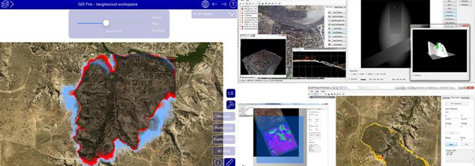
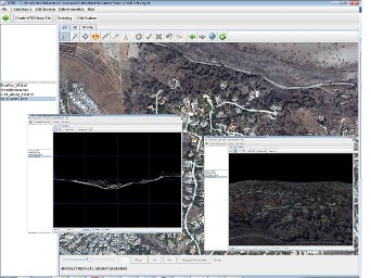
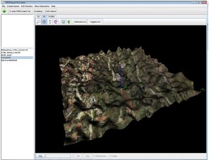
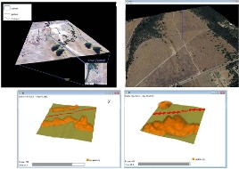
LOOSE INTEGRATION OF wfds-PB & GIS


An identified need by modelers was for the development of a cross-platform application to create WFDS input files from both geospatial data inputs and inputs representing simulated landscapes.  This application would serve as basically a linkage between WFDS and numerous other applications and GIS software platforms.  The application needed to be run on iOS™, Windows™ and Linux™ operating systems. Java™ presented an appropriate choice for development of this application as compiled Java™ programs run on all platforms. Developing underlying geospatial data manipulation and viewing libraries, however, is a complicated task and the use of third party open source libraries was exploited.  For this project the open source Java library GeoTools was used for development.

For the following reasons Java™ was chosen as the development language:

 
  • · Java™ is a truly cross-platform language and will result in a simpler installation without the need to install GIS software, which non-experts often struggle with.
  • · Other cross-platform development environments would result in the need to develop different sets of code for the graphical-user interface (GUI) for each operating system, increasing both development time and maintenance requirements.
  • · There is an open source library called Geotools (Geotools, 2014[i]), which reduced some of the code development particularly in regards to geospatial data manipulation and handling (e.g. coordinate reference systems).

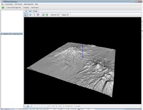
Java™ does hold some memory limitations that would not be encountered when developing in C++ for example.  Nonetheless, the developed application has the capability to view large areas of data and create large WFDS input files, larger than could realistically be run on most computer clusters.  In fact, WFDS input files can be created using the Java™ WFDS Input File Creator, which cannot even be viewed and opened in text editors for editing with a machine with 128GB of memory due to running out of memory.  This, however, points to the need for different data structures for WFDS.

The requirements for data needed to characterize fire behavior and validate fire models in landscape scale settings are in there infancy.  If the understanding of fire behavior increases, requirements for software integrating GIS and fire models might change.  Additionally, as more complex scenarios are validated more complex integration strategies might have to be employed.  Currently, there is limited data publicly available to test such scenarios and this project saw collaborations with WFDS modelers to test the simple fuel and topography cases presented at 2014 Camp Swift research burns.  The software, at a minimum is designed to support cases such as these and likely far more applications.

The production software being developed as part of this project is designed to be scalable and flexible, thereby allowing for changes such as those described above to be incorporated as the science progresses. Changes in integration software, however, should be guided by changes produced from validated fire models, initially, in terms of integrating GIS with WFDS.  It makes little sense to develop integration functionality for the software for data scenarios that are hypothetical and do not come from existing data available to developers or established theory.  

Nonetheless, the software is ready for WFDS modelers to use to examine the feasibility of using geospatial data in WFDS.  The basics of the transfer of geospatial data from high resolution sensors to WFDS can readily be accomplished.  The core algorithms for transferring standard geospatial data to WFDS file formats are found in Appendix B.  

The project developed software can be found on this web page.  Major functionality included in the software is as follows:

  • · 2D viewing of all GIS data
  • · 3D viewing of GIS data portraying LIDAR derivatives, point clouds and other data.
  • · 3D viewing of geospatial data combined with 3D representations of WFDS inputs.
  • · Cross sectional views of GIS data.
  • · Ability to transfer numerous geospatial data formats to WFDS input files.
  • · Ability to display WFDS simulation outputs and convert these to GIS formats.
  • · Ability to compare various calculations of slope from 2.5D to 3D data sets.
  • · Ability to extend the functionality of the program through a Jython™ script editor that allows for the editing and running of scripts[1].  

A help document is associated with the application providing details of all the functionality contained within the application.

Simulated Terrains


The WFDS Input File Creator can be used to incorporate simulated landscapes as shown below.

Example of terrain simulated  with an aerial image overlaid in the WFDS Input File Creator built using a custom script in the Jython script editor.

Simulated terrain from Terrain Blender viewed in the WFDS Input File Creator.


WUI Communities


The WFDS Input File Creator can be used to create model input files for simulations of real world WUI Communities as shown below.

WFDS demonstration simulation of small area at the Trails at Rancho Bernardo Community in Southern California.

WFDS demonstration simulation of wildlands adjacent to the Lake Tanglewood Community in Amarillo, Texas.


Prescribed Fires


The WFS Input File Creator can be used to create model input files for simulations at prescribed research burns as shown below.

WFDS Inputs and demonstration simulations at the 2014 Camp Swift Research Burns.

WFDS Inputs and demonstration simulations at the research burns occurring at Joint Base Lewis McChord.

  • Th

©2013 Geospatial Measurement Solutions, LLC - 2149 Cascade Ave. Ste. 106A PMB 240 Hood River, OR 97031, USA  541-436-4486  dmgeo@gmsgis.com