(208) 818-2152                                                                                                                   dmgeo@gmsgis.com

Geospatial Measurement Solutions, LLC:  Custom software development; database maintenance and development; remote sensing analysis, data collection, mobile technology implementation, and scientific analysis and documentation.

PROJECT HOME INTEGRATING GIS WITH FIRE MODELS WUI DATA COLLECTION WUI REMOTE SENSING

Wildland-Urban Interface (WUI) and Wildland Fire Data Collection

(National Institute of Standards and Technology Fire Research Grant 60NANB11D173)

BACKGROUND & OVERVIEW
EXAMINING US WUI & WILDLAND FIRE DATA SPATIOTEMPORAL WUI DATA COLLECTION

Background & Overview


Data collection is common to all fields of study from the physical sciences to the social sciences in private and governmental sectors. Collection of data in scientific and engineering disciplines occurs to explore a particular study area, answer research questions, test hypotheses and monitor phenomena.  Data collection can occur in quantitative research where the data collection methods are highly structured in a controlled environment leading to reproducible experiments or it can occur in qualitative research were collection methods are unstructured. Data collection can occur in multidisciplinary studies where research is conducted concurrently, interdisciplinary studies where research is integrated or transdisciplinary studies where the integration produces a new science.  For projects involving the integration of data from multiple disciplines in space and time, the Geographic Information Sciences (GISci) provide a framework to gauge the level of interdisciplinary integration.

Data collection can also be used to monitor phenomena such as the number of wildland fires that destroy structures. Regardless of the discipline or type of research or question attempting to answer, collection of data in a scientific manner involves strict adherence to established protocol, even if some protocols are less structured than others, while maintaining objectivity. For example, even qualitative research that attempts to gather information from different groups would not ask each group different questions.

Figure 1:  Data collection and analysis in the WUI and wildlands to improve response, assessments and mitigation.

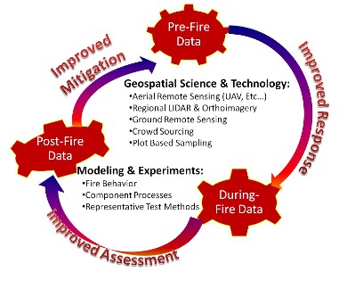
Data collection for the WUI and Wildland fire problems span numerous disciplines and professions and should be an iterative process as shown in Figure 1 to produce improved response to fires, improved assessment of fires and ultimately provide improved mitigation solutions.  Data collected from real world fire incidents requires the application of geospatial science and technology to feed intelligent and useful information for model and experiment development.  Listed below are various key sources of information historically used to gain an understanding of the WUI and Wildland Fire problems:

  • Expert Opinion:  expert opinions from wildland and WUI fire fighters comprises a large part of the information currently available to understand the WUI and wildland fire problems.  Particularly for the WUI this is true where first responders are typically the only witnesses to the incident.
  • Private Citizens:  private citizens can also provide valuable information regarding WUI and wildland fires.  Once again, particularly for the WUI, private citizens might also be present with first responders, though typically only during the evacuation stage of the incident. 
  • Government Data Collection:  Various local, state and federal government sources collect data for monitoring and assessment of the WUI and wildland fire problems.  This involves ground data collection such as information recorded with the Incident Command System 209 Form to satellite based remote sensing of active fires through the MODIS Data Product.
  • Experiments:  wildland fire field experiments are lacking due to most scientists not being versed in interdisciplinary science but rather only their specific discipline, general lack of support for truly integrated interdisciplinary project and logistical difficulties associated with these experiments (Peterson and Hardy, 2016) and the lack of appropriate measurement science.  Experiments assessing building components are in the early stages of development and are hindered by a lack of understanding of exposure conditions present in the WUI (Mell et al., 2010). 

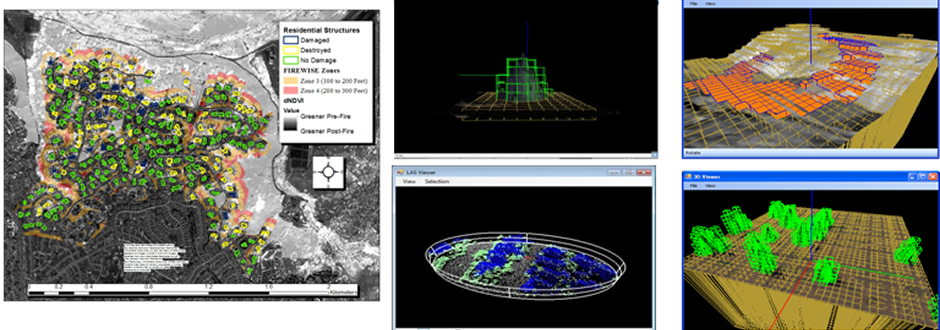
Exploitation of the above data collection sources for understanding the WUI and wildland fire problems are in there infancy.  There are limited tools and techniques to assess the quality and quantity of expert opinions on the WUI and wildland fire problems.  For example, in a recent study of the 2012 Waldo Canyon Fire over 4500 person-hours were spent on technical discussions with first responders to obtain basic information on defensive actions and damaged structures.  More efficient methods to obtain information from expert witnesses on WUI and wildland fires are required as recognized by industry experts (Metcalf, 2015).  Documentation of the above described spatiotemporal data is typically limited with formal geospatial metadata detailing specifics of the data product rarely being produced.

Private citizens applying citizen science is also underutilized in the WUI with some exceptions (e.g. Ferster et al., 2013).  For example, wind patterns through WUI communities are poorly understood.  Recent studies of the Trails at Rancho Bernardo Community have attempted to model wind in this community but due to logistical constraints could only install 17 anemometers.  The locations of these anemometers were driven by the locations of public utility poles and not necessarily optimum placement of sensors for measuring wind across a community.  Private weather stations operated by homeowners could be utilized if placed correctly to more ubiquitously sample wind and weather in WUI communities.  Finally, government data collection, experiments and post-fire assessments suffer from a lack of scientific archival of data collected, lack of collaboration and integration and coordination between scientists (National Science Technology Council, 2015) and multidisciplinary approaches compared to the required interdisciplinary approaches. 

Examine National WUI and Wildland Data

At coarse levels, as described below, in the United States (US) does exist a large amount of fire data with new programs occurring to aid in data integration. At finer scales, such as destruction and damage to the built environment at the parcel level there is little national or regional information available. Fine scale data covering pre-fire, active-fire and post-fire conditions necessary to understand component fire processes and fire behavior as well as validate the next generation of fire models is only beginning to be acquired (e.g Camp Swift Research Burns). Though the above issues cannot be solved with geospatial science and technology alone, the application of this science and technology can provide a foundation for beginning to overcome the above issues.

©2013 Geospatial Measurement Solutions, LLC - 2149 Cascade Ave. Ste. 106A PMB 240 Hood River, OR 97031, USA  541-436-4486  dmgeo@gmsgis.com