Geospatial Measurement Solutions, LLC: Custom software development; database maintenance and development; remote sensing analysis, data collection, mobile technology implementation, and scientific analysis and documentation.
Remote Sensing in the Wildland-Urban Interface (WUI) (National Institute of Standards and Technology Fire Research Grant 60NANB11D173)
Remote Sensing for Post-Fire Assessment Remote sensing provides many opportunities for assessment of the post-fire environment. Significant effort, however, is still required to develop robust correlations between remotely sensed estimates of post-fire effects across varied environments. Nonetheless, Chu and Guo have provided a review of techniques for monitoring post-fire effects in boreal forest regions (Chu and Guo, 2014). Assessment of the post-fire environment can also be divided into two general categories as portrayed in the Fire Disturbance Continuum and listed below:
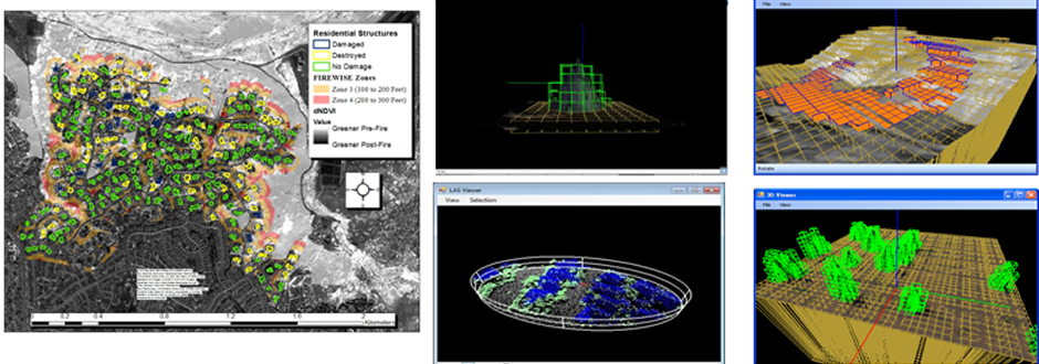
In either case, the post-fire environment is a result of all the contributions from all the environments coming before the post-fire environment. (Jain, 2004). Remote Sensing of Post-Fire Effects at 2014 Camp Swift Research BurnsUnmanned aerial systems (UAS) were utilized at the 2014 Camp Swift Research Burns for mapping of the post-fire environment as shown in the web map to the right. Limited analysis of remote sensing of post-fire effects at the 2014 Camp Swift was conducted but a simple demonstration highlights the utility of simple pre-fire and post-fire multispectral imagery of fire environments. Many prescribed burns, including Camp Swift initially, did not have plans for acquisition of both pre-fire and post-fire imagery. At the recommendation of Dr. William Mell and Geospatial Measurement Solutions throughs this NIST grant, both pre-fire and post-fire multispectral imagery was collected. The pre-fire imagery was essential to mapping fuels as described in the Active-Fire WUI Remote Sensing section. The post-fire imagery was not used extensively but further study could occur. Additionally, a simple excercise can demonstrate the utility of the remote sensing for research burns. Remote Sensing of Post-Fire Effects for WUI EnvironmentsAs described in Maranghides et al (2015), remote sensing was used extensively to assess post-fire effects for the study of the Waldo Canyon Fire. The application of remote sensing for the study of the Waldo Canyon Fire was unique in the field with the study being described as ground breaking by the National Fire Protection Association. Unique to this study of the Waldo Canyon Fire was the application of remote sensing. Never before has the spatiotemporal nature of a WUI scene been characterized to such detail. The use of active fire ground imagery was essential to this characterization. High-resolution post-fire imagery was also essential to the above described study of the Waldo Canyon Fire by highlighting the following indicators of fire behavior and human actions in the built environment during a WUI event:
Other environments could have additional indicators that might help identify spotting fire behavior and defensive actions. Defensive actions are basically never considered fully in the majority of historical fire assessments with some exceptions (e.g. Maranghides and McNamara, 2016, Maranghides et al., 2015; Maranghides et al., 2013). The identification of the above described indicators allows for assessment of historic WUI fires in a different context. |
©2013 Geospatial Measurement Solutions, LLC - 2149 Cascade Ave. Ste. 106A PMB 240 Hood River, OR 97031, USA 541-436-4486 dmgeo@gmsgis.com